The Islands of Squaregridia and Blanksquaresia
This activity for primary-aged children (age 7 onwards) is a treasure hunt with two maps. The Island of Squaregridia has a pre-defined map with a couple of suggested routes which can be used to introduce the game and concepts. The Island of Blanksquaresia is, as the name suggests, a blank map for the class members to create their own treasure map and then communicate the steps and instructions to another class member who’ll try and follow their route to find where they’ve hidden the treasure.
Maps, instructions and algorithms
Computers need precise instructions (an algorithm) to complete a task. If they follow the task exactly they’ll arrive at an expected result. Things can go wrong if the steps in the instructions are mis-communicated. Things can also go wrong even if the instructions are communicated perfectly but followed from the wrong starting point. People might be able to work out how to rescue instructions that aren’t working but a computer doesn’t have that overview and needs to be told every step. Programming is about writing clear instructions.
This activity/game illustrates this concept using the analogy of a treasure hunt on a small imaginary square island. The class (individually, in pairs or in groups) will use a blank 16-square (4×4) grid to create a treasure map by selecting a START square and a STOP (ie the TREASURE) square, and drawing a few TRAPS on other squares to avoid along the way. They’ll then plot a route from START to TREASURE, while avoiding the TRAPS, and communicate this in a step by step way to a ‘visitor’ to their island who’ll plot the route on a fresh copy of the ‘map’ to see if they can find the treasure.
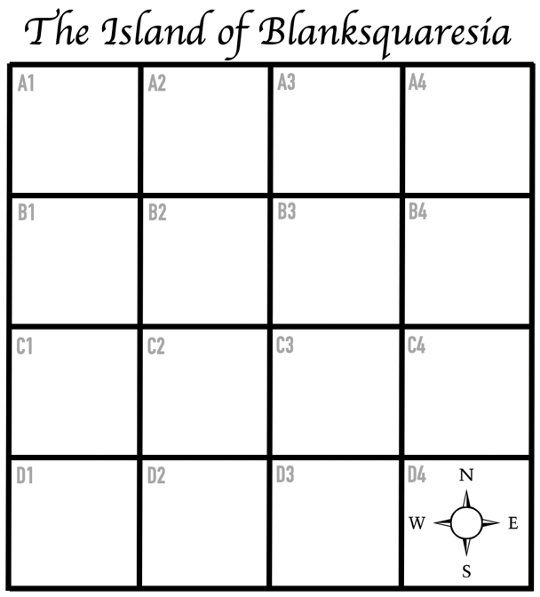
There are two islands – (1) the Island of Squaregridia is an island with a pre-filled map and a couple of suggested routes for practice and (2) the Island of Blanksquaresia is completely blank (other than having a compass rose in one square) for the class to create their own map and communicate a route to someone else.
(1) The Island of Squaregridia
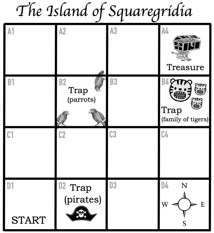
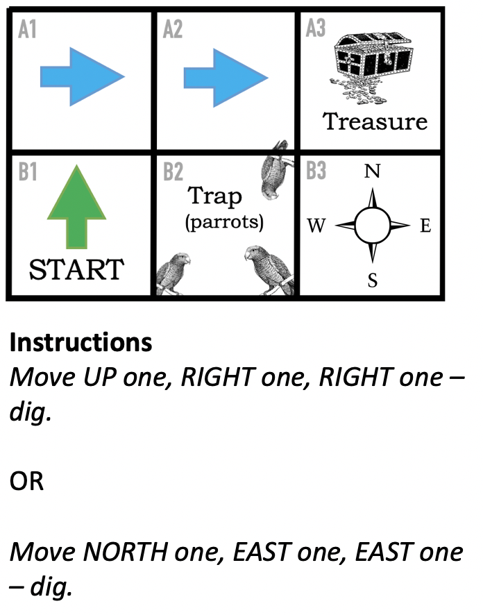
This map has two suggested simple routes which could be run first as a practice run in class, there’s also an optional ‘Test Island’ mini-grid that shows how to communicate the instructions.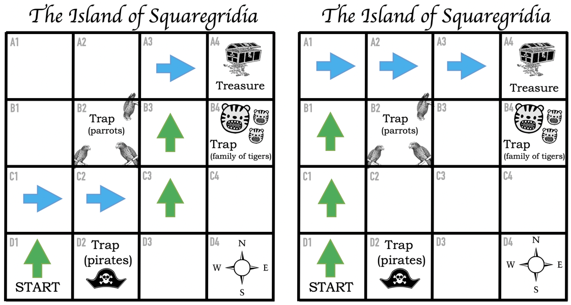
Resources for Squaregridia
The printable activities below include example maps, example routes and test maps for use (4 per page).
- Teachers’ notes for The islands of Squaregridia and Blanksquaresia.docx
- Printable A4 and photocopiable copies of the material for class distribution
[This file – The islands of Squaregridia and Blanksquaresia – contains all the five individual files below in one document]- file 1: Squaregridia mapped.pptx
- file 2: Squaregridia routes.pptx
– two page document: first for colour printers, second for black and white
– can also be used on screen (if option available) instead of printed - (optional) file 3: Test Island.pptx (can be used on screen instead of printed if option available)
– two page document: first for colour printers, second for black and white
– can also be used on screen (if option available) instead of printe - file 4: Squaregridia blank maps.pptx
- (file 5: see below)
You will need
- printed copies of the maps in files 1 and 3 for the class to find the route (file 1) and communicate it to someone who can’t see the full map (file 3)
- pens / pencils to draw a route (or rubber stamps with an arrow or pointing finger could be used)
- a counter or marker (could be a coin!) for moving across the blank map when following someone else’s instructions to find the treasure
(2) The Island of Blanksquaresia
This is a blank map (the starting square is not marked) with just a compass rose (North, South, East, West). People working individually or in groups are given a copy of the blank island on which to create their treasure map (location of START, TREASURE and any TRAPS) and work out the route they want to give someone else (the ‘visitor(s) to their island who are seeking the treasure). They then swap with another person or team and give their instructions verbally so that their visitor(s) can find the treasure using a new blank map. They need to tell the visitor(s) which square they’ll start from (eg “B3”) and in which direction to move for each square.
Everyone (or every team) has two copies of the blank map – one to create their own route on, and one to follow someone else’s route on… plus some spares in case.
Resources for Blanksquaresia
You will need
- printed copies of the blank maps – enough for everyone to design their own individual or group map, and enough for everyone to follow someone else’s instructions on a separate copy of the map
- pens / pencils to draw on the maps and then to draw the route (rubber stamps could also be used)
- Counters / markers (coins) for the ‘visitors’ to use to plot the route
This activity was created with the support of Queen Mary University of London’s Centre for Public Engagement
![]()
