QMUL’s campus is on Mile End Road between Stepney Green and Mile End stations. The venue is in walking distance from either station and buses 25 or 205 will also drop you off nearby.
Stepney Green station: District Line, and the Hammersmith & City Line
Mile End station: Circle Line
Venue
The Bancroft building at QMUL.
What3Words: https://what3words.com/table.storm.line <- download the free What3Words phone app (or use a web browser) and use these words to navigate to the venue.
The building is number 31 on this map (PDF) marked in purple to denote an Educational/Research building.
Route One – from Mile End station
Mile End station – walk or bus to Westfield Way – short walk into campus
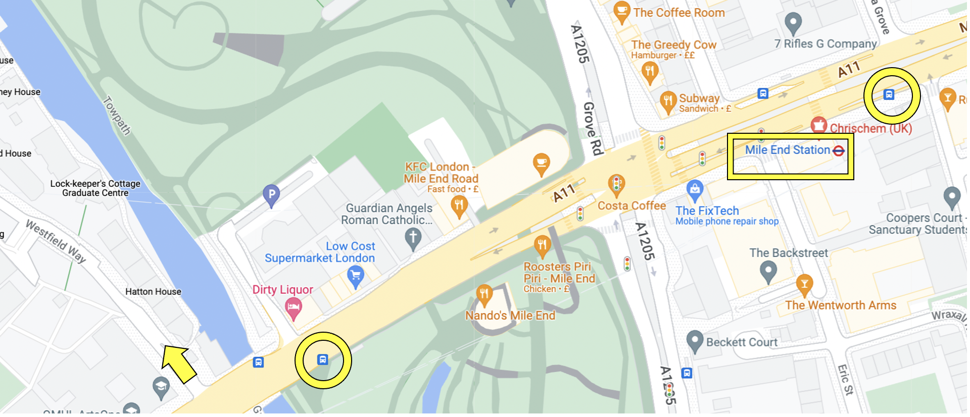 Map showing the first part of the route from Mile End Station
• Alight at Mile End station (highlighted with yellow rectangle in image above)
– If walking, turn left and continue to Westfield Way (yellow arrow), crossing the road (or use the Green Bridge)
– If taking the 25 or 205 bus the first stop (Mile End Stop C) is behind you (yellow circle nearest to the station) and the bus will drop you off one stop later at Regent’s Canal Stop F (also circled in yellow).
• Walk into Westfield Way (yellow arrow) and follow the path in the image below for the Bancroft Building (from yellow arrow to bright green square).
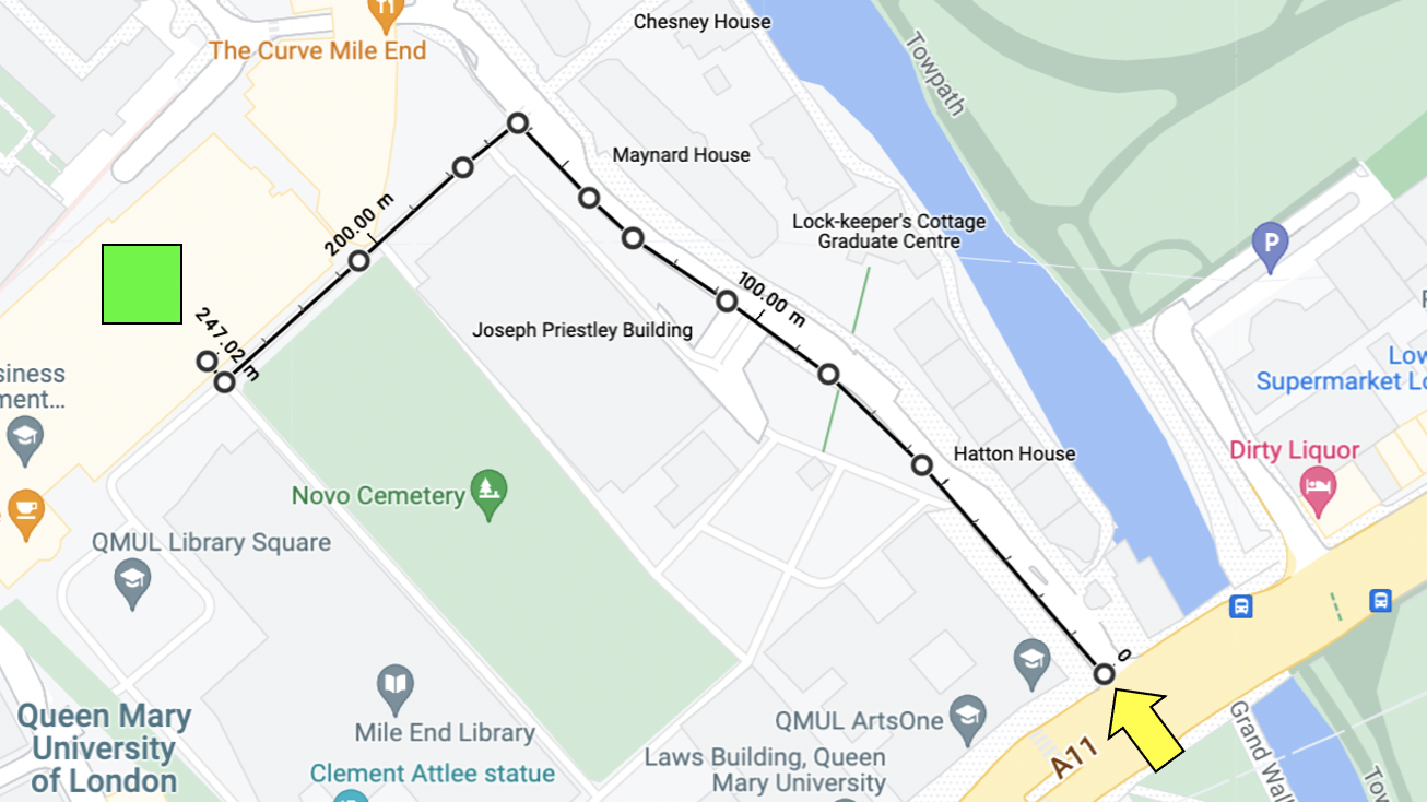
Map showing the second part of the route, from Westfield Way to the Bancroft Building.
Route Two – from Stepney Green station
Stepney Green station – walk or bus to Bancroft Road or Queen’s Building – short walk into campus
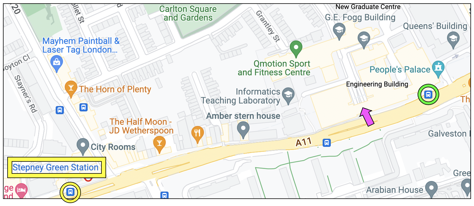
Map showing Stepney Green station and Bancroft Road
• Alight at Stepney Green station (highlighted with yellow rectangle in image above)
– If walking, turn left and continue to Bancroft Road (pink arrow) or further on to the large white Queen’s Building (see picture on the right below)
– If taking the bus, take 25 or 205 from Stepney Green station, stop B (yellow circle) two stops to Queen Mary University Of London (Stop D) marked with a green circle.
• There are several routes in to ‘Library Square’ where the Bancroft Building is; a couple are shown below (left: from Bancroft Road, right: from the Queen’s Building).
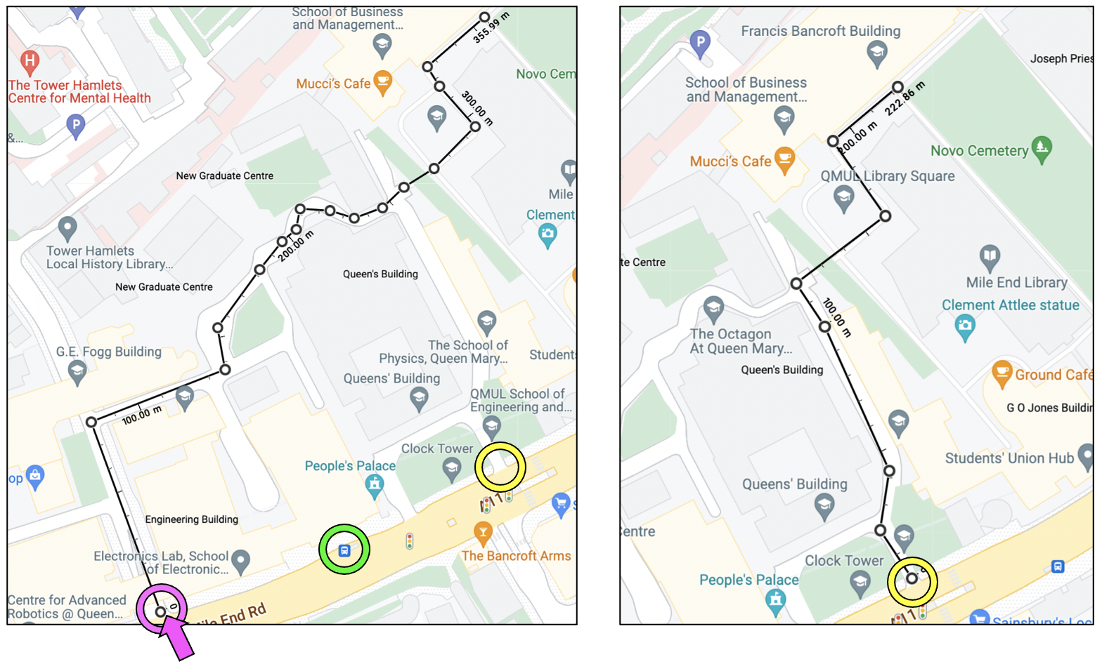
Left: route from Bancroft Road (pink circle / arrow) showing Bus Stop D (green circle)
Right: route in from the Queen’s Building (marked with a yellow circle in both pictures).
Route Three – from Stepney Green station
Stepney Green station – walk or bus to Westfield Way – short walk into campus
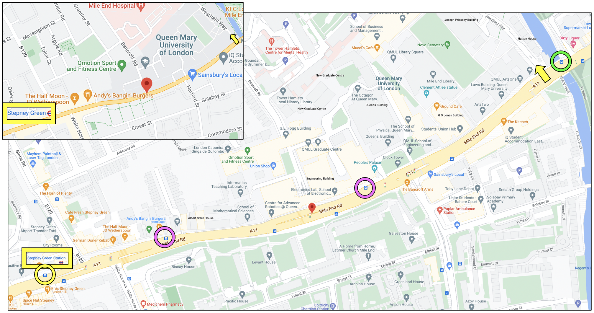
Map showing Stepney Green station and Westfield Way with bus stops highlighted.
• Alight at Stepney Green station (highlighted with yellow rectangle in image above)
– If walking, turn left and continue to Westfield Way (yellow arrow)
– If taking the 25 or 205 bus the first stop (Stepney Green station, stop B) is marked with a yellow circle above. The bus will drop you off at the bus stop marked with a green circle (Regent’s Canal, stop E), walk back to Westfield Way.
• Walk into Westfield Way (yellow arrow) and follow the signs for the Bancroft Building. The route is below (from yellow arrow to bright green square).
Route overlaid over map showing Westfield Way to Bancroft Building.
All map images are copyright to Google Maps.
